Hālawa Valley temples

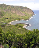
The Hālawa Valley at the eastern end of the Hawaiian island of Moloka‘i is presently covered in dense vegetation. In pre-contact times, though, it was a major centre of irrigated taro cultivation. It contains several temple sites (heiau) ranging from small shrines (ko‘a), through various mid-sized agricultural or fertility temples (heiau ho‘oulu‘ai), up to a major luakini temple of human sacrifice. It is unusual to find the full hierarchy of temples evidenced within a single territorial unit (ahupua‘a).
In 2019 Pat Kirch and I relocated and mapped ten heiau that had first been surveyed by archaeologist John F. G. Stokes in 1909. Most of them are terraces or terraced platforms in architectural form, ranging in size from 72 to 1300 m2. Working with colleague Jillian Swift, Kirch subsequently test excavated and radiocarbon dated seven of them.

Our surveys showed that the orientations of the temple foundations appear to be deliberate (rather than dictated by topography) and conform to the pattern found in the Kahikinui and Kaupō districts of the adjacent island of Maui (see Heiau, ‘Āina, Lani, p. 133):
- One group is slightly offset from cardinality and shows an eastward orientation, likely associated with the god Kāne. This accords with the valley’s emphasis on the irrigated cultivation of taro, as Kāne is the deity associated with both flowing waters and with the taro plant.
- A second group of temples exhibits an orientation to the ENE, which is the direction of the Pleiades star cluster (Makali‘i), whose achronycal rising determined the onset of the Makahiki season dedicated to the god Lono.
The radiocarbon dates indicate that the temples were constructed during the seventeenth to eighteenth centuries, or the Archaic States Period of the Hawaiian cultural sequence.
From Mana Heaiu, the largest in the area, there is an open view in the ENE direction that it faces. This is now obscured by trees but in their absence would be towards the sea horizon in the mouth of the valley, framed by the ridges to the N and S. At the time of construction, Makali‘i would have risen from the sea horizon at an azimuth of about 66°, as shown by the blue and yellow line in the figure. Another point of interest at this heiau is that the foot of the cliffs where the southern ridgeline of the valley meets the sea is very close to due east or the equinox sunrise.

One of the temples (Papa Heiau), on the other hand, falls outside both orientation groups and may have been a “college of priests” oriented towards the kapu abode of the famous sorcerer priest Lanikaula.
The research has been published in a paper entitled The Precontact Temple System of Hālawa Valley, Moloka‘i, Hawaiian Islands in the on-line journal Archaeology in Oceania.


 If you are looking for things related to Alice and/or information about stalking, please visit the